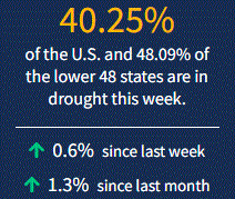
Wet conditions have continued to slowly improve drought in northern California and the Northwest. However, most of the West maintained status quo. Across the U.S., Wisconsin and Michigan and the Carolinas saw drought worsen. As of November 9, 2021, 40.3% of the U.S. and 48.1% of the lower 48 states are in drought.

Looking Ahead
The Weather Prediction Center’s forecast (valid November 10 – 16) calls for multiple rounds of precipitation in the Pacific Northwest. These events are expected to bring heavy rain with local areas of flash flooding. Snow is expected over the high elevations of the Pacific Northwest to the Upper Midwest. A cold front sweeping across the eastern half of the country will bring showers and thunderstorms to the South and rain and rain to much of the East. As the front moves through, temperatures will drop 2 – 5 degrees below normal in the central part of the country and 4 – 9 degrees cooler than normal across the Lower Midwest and Southeast. Temperatures will be 5 – 11 degrees warmer than normal across the West.
The Climate Prediction Center’s 6 - 10-day outlook (valid November 16– 19) favors an active storm track across the northern tier of the Lower 48. This pattern would bring above-normal rainfall to the Pacific Northwest eastward to the Upper Midwest. Below-normal precipitation is likely across the southern tier of the Lower 48, with the greatest odds (more than 50%) over parts of the Southwest, the Southeast, and Alaska. The highest odds for above-normal temperatures occur in the Southwest (greater than 70%). Odds of above-normal temperatures decrease moving northward. The highest odds for below-normal temperatures occur in the Southeast (greater than 60%). Odds of below-normal temperatures decrease across the South and Midwest.


